O'Hare West Bypass
| |
|---|---|
| Route information | |
| Maintained by IDOT | |
| Major junctions | |
| South end: |
|
| North end: |
|
| Highway system | |

Route description
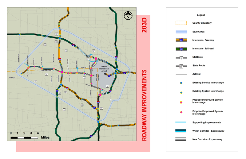
The O'Hare West Bypass, also known as Interstate 490, is a proposed electronic toll highway near Chicago that would run along the west side of O'Hare International Airport.[1] The tollway would connect Interstate 294 (I-294, the Tri-State Tollway) to a western access point to the airport. From there, it would continue northward to an extension of the Illinois Route 390 and I-90 (Jane Addams Memorial Tollway). Building the highway would affect the villages of Elk Grove Village, Wood Dale, Itasca and Bensenville.[2]
In December 2009, IDOT finalized the routing of the western bypass.[3] Intermediate interchanges are planned at County Line Road/Franklin Avenue, IL 19, IL 390 and IL 72.[4]
On August 25, 2011, the Illinois State Toll Highway Authority (ISHTA) approved a $12 billion capital plan, doubling toll rates to fund it.[5] The American Association of State Highway and Transportation Officials approved the Interstate 490 designation in November 2014, contingent on Federal Highway Administration approval.[4]
Construction will begin in 2018 and will be completed in 2025.
See also
- Chicago portal
- Illinois portal
- U.S. Roads portal
References
- ↑ Meincke, Paul (July 14, 2011). "O'Hare bypass likely to increase Illinois tolls". Chicago: WLS-TV. Retrieved December 24, 2011.
- ↑ Roadway Improvements 203D (Map). Illinois Department of Transportation. Retrieved December 24, 2011.
- ↑ Pyke, Marni (December 19, 2009). "IDOT passes on Bensenville for western bypass around O'Hare". Daily Herald (Arlington Heights, IL). Retrieved March 23, 2010.
- 1 2 Johnson, Greg (November 20, 2014). "Report to SCOH" (PDF) (Report). Charlotte, NC: American Association of State Highway and Transportation Officials.
- ↑ Rozek, Dan (August 28, 2011). "Tollway OKs 87 percent toll increase". The Courier-News. Retrieved August 28, 2011.