St George, Bristol
| St George | |
 Boundaries of St George West and East wards, shown within Bristol. |
|
| Population | 11,348 (2001.Ward)(East)[1] 10,929 (2001.Ward)(West)[2] |
|---|---|
| OS grid reference | ST626734 |
| Unitary authority | Bristol |
| Ceremonial county | Bristol |
| Region | South West |
| Country | England |
| Sovereign state | United Kingdom |
| Post town | BRISTOL |
| Postcode district | BS5 |
| Dialling code | 0117 |
| Police | |
| Fire | |
| Ambulance | |
| EU Parliament | South West England |
| UK Parliament | Bristol East |
Coordinates: 51°27′31″N 2°32′19″W / 51.4586°N 2.5385°W
St. George is a district of Bristol, England on the edge of the inner city.
St George was originally in Gloucestershire. It became a civil parish (formally known as Bristol St George) in 1866, and briefly an urban district from 1894 to 1898. The parish and urban district were absorbed into Bristol in 1898.[3]
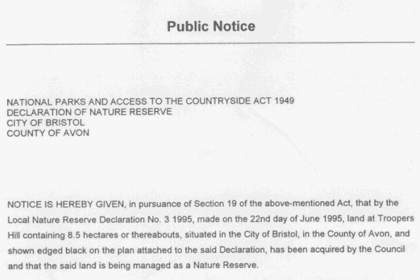
Troopers' Hill is a local landmark, and was a mining area from the early 19th century (coal) until its closure in 1904 when the last fireclay mines were abandoned.[4] It was declared as a Local Nature Reserve (LNR) on 22 June 1995.[5]
St George was outside the city boundary until 1860 and it marked the end of the tram line from Bristol, the terminus being in Beaconsfield Road. Nowadays, the area is not so much out on a limb, but is still a community in its own right, with plenty of shops and pubs, while the abandoned chimney at Troopers Hill serves as a prominent landmark.
Its history is caught up in mining, which began in the early 19th century and ran until 1904, when the last fireclay mines were abandoned. Now only pit names remain as a reminder, such as Deep Pit Road.
John Armitstead, a colliery proprietor, had a pit between Church Road and Whitehall Road, where he installed a pumping engine for raising coal. Power was generated from water by means of a fire and the device was called a fire engine. It stood on land which came to be known as the Engine Ground and there is still a pub nearby called the Fire Engine.
The St George Fountain is a Victorian construction which divides the main Church Road which forks at this point to Kingswood and Hanham. The road was also once the boundary between Bristol and Gloucestershire.
- ↑ "St George East" (PDF). 2001 Census Ward Information Sheet. Retrieved 2007-02-21.
- ↑ "St George West" (PDF). 2001 Census Ward Information Sheet. Retrieved 2007-02-21.
- ↑ Vision of Britain: St George UD
- ↑ "Friends of Troopers Hill". Retrieved 2009-04-21.
- ↑ "Public Notice". Retrieved 2009-04-21.