Wayanad district

| Wayanad district വയനാട് ജില്ല | |
|---|---|
| District | |
 | |
 Location(Marked Black) in Kerala, India | |
| Coordinates: 11°36′18″N 76°04′59″E / 11.605°N 76.083°ECoordinates: 11°36′18″N 76°04′59″E / 11.605°N 76.083°E | |
| Country |
|
| State | Kerala |
| Headquarters | Kalpetta |
| Government | |
| • Member of Parliament | M I Shanavas |
| • District Collector | Keshavendra Kumar IAS |
| • District Panchayat President | N.K. Rasheed |
| Area | |
| • Total | 2,131 km2 (823 sq mi) |
| Population (2011) | |
| • Total | 816,558 |
| • Density | 380/km2 (990/sq mi) |
| Languages | |
| • Official | Malayalam, English |
| Time zone | IST (UTC+5:30) |
| ISO 3166 code | IN-KL- |
| Vehicle registration | KL-12, KL-72, KL-73 |
| Website |
www |
Wayanad District is a district in the north-east of Kerala state, India with headquarters at the town of Kalpetta. The district was formed on 1 November 1980 as the 12th district in Kerala by carving out areas from Kozhikode and Kannur districts. The district is 3.79% urbanised, with three municipal towns Kalpetta, Mananthavady and Sulthan Bathery.
Wayanad district is in the southern tip of the Deccan Plateau. Part of the Western Ghats is in the district. In the centre of the district hills are lower in height while the northern area has high hills. The eastern area is flat and open.
The region was known as Mayakshetra (Maya's land) in the earliest records. Mayakshetra evolved into Mayanad and finally to Wayanad.[1] The Folk etymology of the word says it is a combination of Vayal (paddy field) and Naad (land), making it 'The Land of Paddy Fields'. There are many indigenous tribals in this area.[2]
It is set high on the Western Ghats with altitudes ranging from 700 to 2100 m.[3][4]
It is the least populous district in Kerala.[5]
Unlike all other 13 districts of Kerala, in Wayanad district, there is no town or village named same as the district (i.e., there is no "Wayanad town").
History

According to archaeological evidence, the Wayanad forests have been inhabited for more than 3,000 years. Historians are of the view that human settlement existed in these parts for at least ten centuries before Christ. Much evidence of New Stone Age civilisation can be seen in the hills throughout the present day Wayanad district. The two caves of Ampukuthimala (Edakal Caves) in Sulthan Bathery, with pictures on their walls and pictorial writings, speak volumes of a bygone civilization. At the foot of the Edakal Male (hill) caves, Kannada inscriptions belonging to Kutumbiya clan of Mysore dating to c. 500 CE were discovered which read - 'Palapulitaanamtakaari', 'Sri Vishnu Varma Kutumbiya Kulavardhanasya li..it..a..'. As per Hultzch, an epigraphist from the department of epigraphy, Madras, it speaks of the glorious descendant of Kutumbiya clan, Kannada chieftain, Vishnu Varma, as one who killed many tigers.[6][7][8] The recorded history of this district exists only from the 10th century onward. In 930 AD, emperor Ereyappa of Ganga Dynasty led his troops to south west of Mysore - an invasion to the prosperous kingdom he had heard of from traders and Jain monks. Mission accomplished and he called the conquered kingdom ‘Bayalnad’ meaning the land of swamps. After Ereyappa, his sons Rachamalla and Battunga (or Butuga) fought each other for the new kingdom of their father’s legacy. Rachamalla was killed and Battunga became the undisputed ruler of Bayalnad. In the 11th century AD, Gangas were dethroned from Bayalnad by Kadamba dynasty[9] of North Canara.[10] Wayanad was at that time divided into two portions - Bira Bayalnad and Chagi Bayalnad. One of the Mysore inscriptions (alluding perhaps to the treacherous beauty of the country, which attracted the stranger and then laid him low with malaria) says 'an adulteress with black waving curls, as adulteress with full-moon face, an adulteress with endless side-glances, an adulteress with adorned slim figure was this storeyed mansion, the double Bayalnad'.[11] Kadamba Bayalnad emerged as a rule in the 11th century under their chief Raviyammarasa with Kirttipura in Punnad their capital. Kanthirava (1090 CE) was described as ruling Chagi-Bayalnad. Iravi-Challamma (1108 CE) was the ruler of Bira-Bayalnad.[12] In 1104 AD Vishnuvardhana of Hoysala invaded Bayalnad followed by Vijayanagara dynasty in the 14th century. A Kadamba king, Mukkanna-Kadamba ruled Bayal-nad in and around 1138 CE.[13] A feudatory chieftain of Sangama dynasty of Vijaynagar, Immadi Kadamba Raya Vodeyayya of Bayalnad Kadambas, is said to have ruled Bayalnad.[12] In 1610 AD Udaiyar Raja Wadiyar of Mysore drove out Vijayanagara General and became the ruler of Bayalnad and the Nilgiris. Bayalnad is the present Wayanad. When Wayanad was under Hyder Ali’s rule, the ghat road from Vythiri to Thamarassery invented.[14] Then the British rulers developed this route to Carter road.[15] When Wayanad was under Tipu Sultan's rule British invasion started. Tussle and turbulent times followed. The British claimed Wayanad under the 1792 treaty of Srirangapatna citing it was part of Malabar. Tipu Sultan went in appeal before the Governor General. Considering his arguments, relying on the successive Karnataka rule for centuries in Wayanad and its geographical detachment from Malabar, in 1798, Governor General Lord Mornington declared by proclamation[16] that Wayanad had not been ceded to the East India Company by the treaty of 1792. Consequently, the British troops withdrew from Wayanad conceding to Tipu’s rule. In 1799, after the fall of Sultan, the British handed over Wayanad by treaty of 1799 to the Raja of Mysore. But by a supplementary treaty dated 29 December 1803 the East India Company repossessed Wayanad and thereafter administrated by Col. Arthur Wellesley from Srirangapatna and North Wayanad came under the rule of the Pazhassi Raja dynasty of ancient Kottayam. Wayanad eventually became part of Kerala despite its geographical delimitations and political descent in 1956 on State’s reorganisation. Even now there is a considerable Kannada speaking population and the reminiscence of centuries old Karnataka rule is omnipresent in Wayanad. Agriculture Cultivation started broadly after 1900 A.D onwards. The British authorities opened up the plateau to cultivation of tea and other cash crops by constructing roads across the dangerous slopes of Wayanad, to Kozhikode and Thalassery. Later, they extended these new roads to the cities of Mysore and Ooty through Gudalur. Settlers emigrated from all parts of Kerala and the fecund lands proved a veritable goldmine with incredible yields of cash crops. When the State of Kerala came into being in November 1956, Wayanad was part of Kannur district. Later, south Wayanad was added to Kozhikode district. To fulfil the aspirations of the people of Wayanad for development, North Wayanad and South Wayanad were carved out and joined together to form the present district of Wayanad. This district came into being on 1 November 1980 as one the twelve districts of Kerala,[17] consisting of three taluks; Vythiri, Mananthavady, and Sulthan Bathery.

Cities and Towns
- Kalpetta, 31,580 people. Capital of the district
- Mananthavady, 37,836 people
- Pulpally, 30,035 people
- Sultan Bathery, 27,473 people
- Padinharethara, 15,174 people
- Panamaram, 11,651 people
- Meenangadi
- Ambalavayal
Tourist Places
- Eddakkal Caves
- Ambalavayal Heritage Museum
- Banasura Sagar Dam(Asia's 2nd Largest Earth Dam and India's Largest)
- Pookode Lake
- Kuruva Island
- Meenmutty Waterfalls
- Sentinal Rock Waterfalls
- Kanthanpara Waterfalls
- Karapuzha Dam
- Chembra Peak,the highest peak in Wayanad, at 2,050 m above sea level.
- Muthanga Wildlife Sanctuary
- Tholpetty Wildlife Sanctuary
- Karalad Lake
- Phantom Rock
Religious Sites
- Thirunelly Temple and Papanashini,Thirunelly, it is believed that the temple is more than 1000 years old.
- Valliyoorkkavu Bhagavathi Temple,It is an important worship place for the Wayanad tribal communities.[18]
- Lourde Matha Shrine,Pallikunnu Church,was built by a French priest Fr. Jefreno in 1908.[19]
- Varambetta Mosque Mananthavady,an old Mosque which is about 300 years old.[20]
- Malankarakunnu St.Thomas Jacobite Syrian Church,Oldest Syrian Orthodox Church in Malabar region.
- Seetha Lava Kusha Temple, Temple is a place dedicated to celestial worship and has a distinctive position among the Kerala temples.[21]
- Puliyarmala Jain temple,This temple is also called as Anathanatha swami temple.[22]
- Assumption Forane Church, Sulthan Bathery,French Missionaries who started the church in 1900.
- Mor Baselious Jacobite Syrian Church, Cheeyambam,Pulpally On foot Pilgrimage from churches in Malabar on fest of St.Yeldho Mar Baselios.
- EAE St.Marys Soonoro Pilgrim Church Meenangadi ,Holds The Soonoro of St.Mary and relics of Patriarch H.H Ignatius Elias III.
Geography
Wayanad district stands on the southern tip of the Deccan plateau and includes part of the Western Ghats. Quite a large area of the district is covered by forest but the continued and indiscriminate exploitation of the natural resources point towards an imminent[23] environmental crisis. It has a large amount of dry and moist deciduous forest. Wayanad is home to endangered species.


Rivers
The Kabini River, one of the three east flowing rivers of Kerala, is an important tributary of the Kaveri River. Almost the entire Wayanad district is drained by Kabini and its three tributaries, the Panamaram, Mananthavady, and Kalindy rivers. The Banasura Sagar Dam is built on one of the tributaries of the Kabini River.
Economy

In 2006, the Ministry of Panchayati Raj named Wayanad one of the country's 250 most backward districts (out of a total of 640).[24] It is one of the two districts in Kerala currently receiving funds from the Backward Regions Grant Fund Programme (BRGF).[24]
Demographics

According to the 2011 census Wayanad district had a population of 816,558,[5] roughly equal to the nation of Comoros.[25] This gives it a ranking of 482nd in India (out of a total of 640).[5] The district has a population density of 383 inhabitants per square kilometre (990/sq mi).[5] Its population growth rate over the decade 2001–2011 was 4.6%.[5] Wayanad has a sex ratio of 1035 females for every 1000 males,[5] and a literacy rate of 89.32%.[5] Badagas are present in 21 hamlets spread across Wayanad.[26] The entire Wayanad region falls under the Kannada speaking area as per the linguistic survey and history of Colonel Wilks.[27]
Administration

District Headquarters: Kalpetta. District Collector, District Police Chief and District Judge are based at Kalpetta.
No. of Taluks: 3
- Vythiri (Headquarters: Kalpetta)
- Sulthan Bathery
- Mananthavady
No. of state Assembly Legislators: 3[28]
- Kalpetta - Current MLA is Mr. M.V. Sreyams Kumar
- Sulthan Bathery - Current MLA is Mr. I.C. Balakrishnan
- Mananthavady - Current MLA is Ms. P.K. Jayalakshmi
Lok Sabha Representation: 1
- Wayanad Lok Sabha constituency - Current Member of Parliament is Mr. M. I. Shanavas.
Access
Road
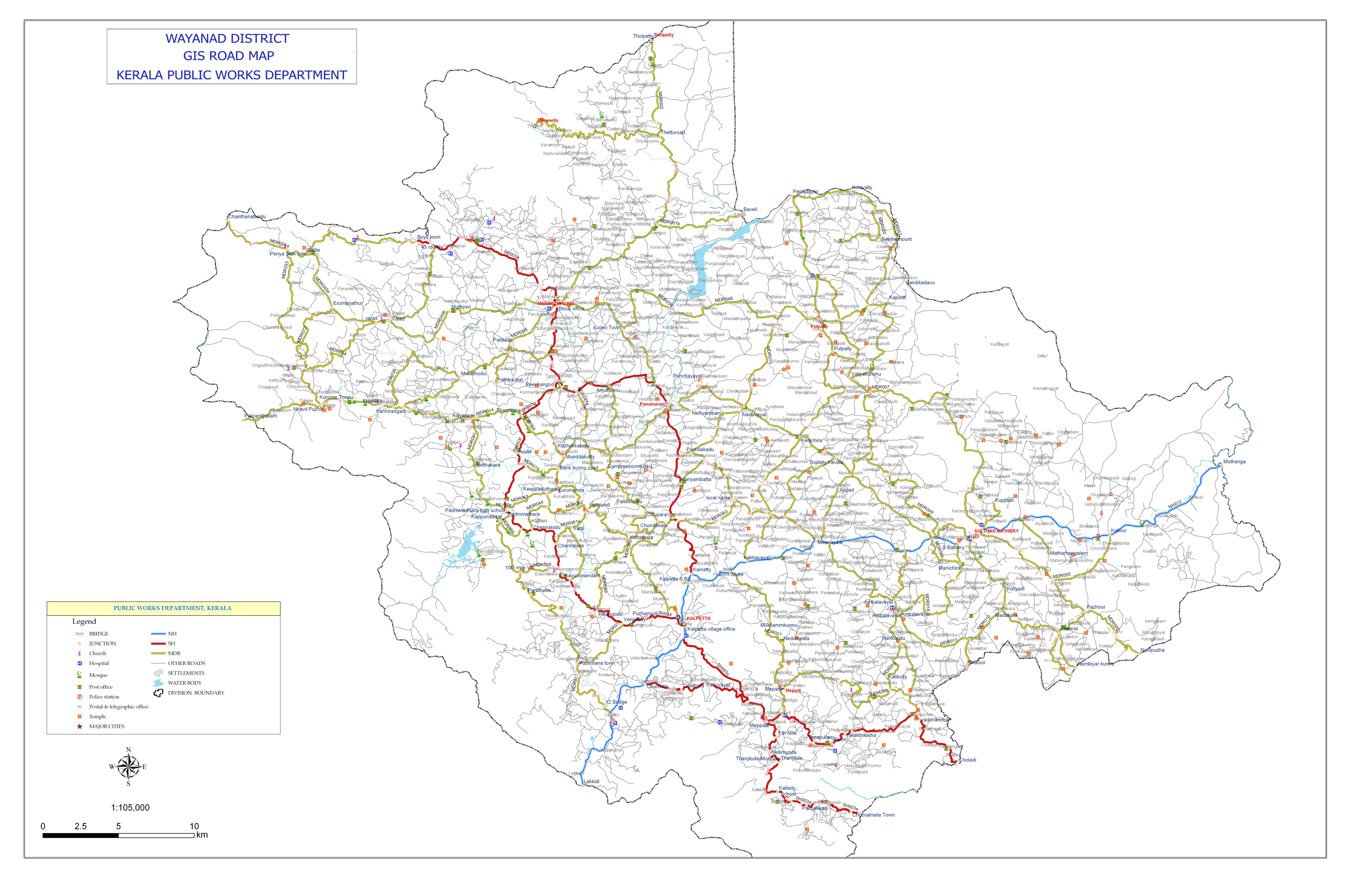
The Kozhikode–Mysore National Highway 212 (NH 212) passes through Wayanad district. This highway is the primary access to Wayanad from the major cities of Kerala (Kozhikode, Kochi and Thiruvananthapuram) as well as Karnataka (Bangalore and Mysore).[29] [30]
State Highways passing through Wayanad are:
- State Highway SH 29 connects to the road to Gudalur and Ooty at the "Kerala - Tamil Nadu state border". This highway was originally Kozhikode - Vythiri - Kerala State border however the section Kozhikode - Chundale is now part of NH212. This highway now starts at Chundale near Kalpetta.
- State Highway SH 54 is an alternate road connecting Kalpetta with Kozhikode. This highway starts at Kalpetta and proceeds to Kozhikode through Padinjarethara, Poozhithode, Peruvannamuzhi, Perambra and Pavangad, Kozhikode. Note that the section Padinjarethara to Poozhithode is not yet laid as the environmental clearance to build the road through the forest is pending.[31]
- State Highway SH 59 Hill Highway (Kerala) - This proposed highway connects both ends of Kerala state, passing through entire hilly regions of the state. This highway will connect Wayanad with Kannur district to the North and Malappuram district to the South. In Wayanad, this highway passes through Mananthavady, Kalpetta and Meppadi. The section connecting Meppadi with Nilambur in Malappuram district is to be built. Note that currently there is no direct road link between Wayanad and Malappuram, though these are neighbouring districts.
All national and state highways passing through Wayanad District intersect at its headquarters Kalpetta,[32] making it the "Gateway of Wayanad".
Night traffic ban on NH 212 at Bandipur National Park
En route to Mysore on NH 212, past Wayanad district boundary, which is also the Kerala state boundary, NH 212 passes through Bandipur National Park. There is a night traffic ban imposed on this stretch since 2009.[33] The alternate road to take is, leave NH 212 at Kalpetta and proceed to Mysore through Mananthavady, Kutta, Gonikoppal, and Hunsur.
Railway
Wayanad district is not connected by rail network but the Railway is Under Progress Nanjangud-Sulthan Bathery-Nilambur Railway Line is approved . The nearest railway station is at Kozhikode, 72 km from Kalpetta. Other railway stations near to Wayanad are Thalassery (80 km from Mananthavadi), Kannur (93 km from Mananthavadi) and Mysore (110 km from Mananthavadi and 115 km from Sultan Bathery).[34]
Airport
Kozhikode International Airport at Karipur is the nearest airport, 95 km from Kalpetta. Kannur International Airport, under construction at Mattannur is at a distance of 70 km from Mananthavady. There is a proposal for new feeder airport in the Wayanad district is at Cheekkalloor (11°43′37″N 76°05′35″E / 11.727°N 76.093°E)[35] in Panamaram and the nearby Nadavayal.[36]
See also
- Kodagu
- Malabar
- List of Temples in Wayanad District
- List of educational institutions in Wayanad district
References
- ↑ Wayanad Rekhakal by O. K. Johnny, Mathrubhumi Books
- ↑ "Kerala Tourism".
- ↑ "Wayanad".
- ↑ "Wayanad Map" (PDF). 2008. Retrieved 7 September 2008.
- 1 2 3 4 5 6 7 "District Census 2011". Census2011.co.in. 2011. Retrieved 30 September 2011.
- ↑ Aiyappan, A. (1992). The Paniyas: An Ex-slave Tribe of South India. The University of Michigan: Institute of Social Research and Applied Anthropology. pp. 20, 28–29, 80.
- ↑ Peter, Jenee (24 October 2015). "Multidisciplinary Documentation of Rock Art and its Allied Subjects in Kerala" (PDF). INDIRA GANDHI NATIONAL CENTRE FOR THE ARTS. IGNCA. p. 2.
- ↑ Mathpal, Yashodhar (1998). Rock Art In Kerala. The University of Michigan: Indira Gandhi National Centre for the Arts. p. 28. ISBN 9788173051302.
- ↑ The Kadamba Kula, A History of Ancient and Mediaeval Karnataka, By George M. Moraes, BX Furtado & sons, Bombay, 1931.
- ↑ "The Kadamba Kula". Internet Archive.
- ↑ Francis, Walter (1908). Madras District Gazetteers: The Nilgiris 1. New Delhi: Asian Educational Services. pp. 90–94, 102–105. ISBN 978-81-2060-546-6.
- 1 2 Nimkar, Madhu (18 September 2009). "Kingdom of Kadambas". History of India. Atom.
- ↑ Rice, B. Lewis (1902). Epigraphica Carnatica (PDF). Mangalore: Government of India. pp. 24, 28, 32.
- ↑ Madrass District Gazetteeers, The Nilgiris. By W. Francic. Madras 1908 Pages 90-104
- ↑ Report of the Administration of Mysore 1863-64. British Parliament Library
- ↑ Proclamation No:CLXXXLL, A. Collection of treaties and engagements, By W.Logan, Calicut 1879
- ↑ "Official Web Site of Wayanad District". ayanad.nic.in. Retrieved 2014-01-29.
- ↑ http://www.wayanadtravel.com/where-to-go/valliyoorkavu-temple/
- ↑ http://www.keralatourism.org/wayanad/pallikunnu-church-meenangadi.php
- ↑ http://www.wayanadtravel.com/where-to-go/varampetta-mosque/
- ↑ http://www.wayanadtravel.com/where-to-go/seetha-lava-kush-temple/
- ↑ http://www.wayanadtravel.com/where-to-go/puliyarmala-jain-temple/
- ↑ "ingentaconnect Consuming the Forest in an Environment of Crisis: Nature Tourism,...". ingentaconnect.com. Retrieved 2014-01-29.
- 1 2 Ministry of Panchayati Raj (8 September 2009). "A Note on the Backward Regions Grant Fund Programme" (PDF). National Institute of Rural Development. Retrieved 27 September 2011.
- ↑ US Directorate of Intelligence. "Country Comparison: Population". Retrieved 1 October 2011.
Comoros 794,683 July 2011 est.
- ↑ Hockings, Paul; Pilot-Raichoor, Christiane (1992). A Badaga-English Dictionary. Walter de Gruyter. p. 514. ISBN 9783110126778.
- ↑ Imperial Gazetteer of India, v. 9, p. 301. DSAL. pp. p. 301.
- ↑ "Assembly Constituencies – Corresponding Districts and Parliamentary Constituencies" (PDF). Kerala. Election Commission of India. Retrieved 18 October 2008.
- ↑ "Bangalore to Mananthavady via HD Kote". www.paru.in. Retrieved 2014-06-14.
- ↑ "Bangalore to Wayanad". www.paru.in. Retrieved 2014-06-14.
- ↑ "Padinajrethara Poozhithode road". The Hindu. Retrieved 2014-05-02.
- ↑ "Road map of Wayanad district". Kerala PWD. Retrieved 2014-05-02.
- ↑ "Bandipur-road-to-be-closed-at-night". DNA India. Retrieved 2014-05-11.
- ↑ "Train to Wayanad". www.paru.in. Retrieved 2014-06-14.
- ↑ "Protests mounting against Panamaram airport in Kerala". Retrieved 2013-10-09.
- ↑ "Feeder airport proposed in Wayanad". Retrieved 2013-06-17.
External links
| Wikimedia Commons has media related to Wayanad district. |
| Wikivoyage has a travel guide for Wayanad District. |
 |
Kannur district | Kodagu district, Karnataka | Mysore district, Karnataka | |
| |
Chamarajanagar district, Karnataka | |||
| ||||
| | ||||
| Kozhikode district | Malappuram district | Nilgiris district, Tamil Nadu |